Stephen's Map Catalog
Friday, April 22, 2011
DOQQ
http://www.lib.ncsu.edu/gis/doqq.html
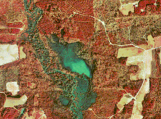
DOQQs or Digital Orthophoto Quarter Quads are digital areal images produced by the USGS. They generally contain orthorectified aerial photography at a resolution of 1 meter. The map above is a color infrared DOQQ of Johnston County in 1998.
No comments:
Post a Comment
Newer Post
Older Post
Home
Subscribe to:
Post Comments (Atom)
No comments:
Post a Comment